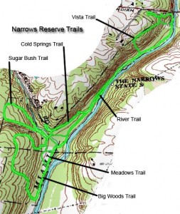
Click on Narrows Reserve Trail Map for Larger View
This is a little gem that I am surprised when people say they don’t know about it or have never been there. The Narrows is run and maintained by the Greene County Park District. The park address is 2575 Indian Ripple Road, Beavercreek, Ohio 45440. It’s easy to find. The entrance is directly across from where Factory Road dead ends into Indian Ripple Road.
It is only a short drive from my house and is my default hiking spot. In total there are about five miles of trails. The main trail runs along the Little Miami State and National Scenic River with five loops. The various trails can be broken down in numerous ways from a completely flat 2.5 mile hike to an easy to moderate 5 mile hike or run. The Narrows is a favorite of runners and is the location of an annual Narrows 5 Miler, in November, sponsored by the Ohio River Road Runners Club (ORRRC). It also has a canoe launch area for the Little Miami River.
Trail Guide: Length and Difficulty
The trails at the Narrows, in general, are easy to moderate in difficulty to hike except for the three trails with steep inclines; the Vista, Sugar Bush, and Big Woods Trails which have difficult sections. Keeping in mind all of the trails, with difficult sections are loops. You can reduce the difficulty of the tougher trails by hiking the trail in the opposite direction making the steepest section, a downhill.
Trail length and difficulty
- River Trail • 1.25 miles • easy
- Vista Trail (clockwise) • .50 miles • moderate to difficult
- Vista Trail (counterclockwise) • .50 miles • moderate
- Cold Springs Trail • .25 miles • easy
- Sugar Bush Trail (clockwise) • .50 miles • moderate to difficult
- Sugar Bush Trail (counterclockwise) • .50 miles • moderate
- Meadow Trail • .25 miles • easy
- Big Woods Trail (clockwise) • .75 miles • moderate to difficult
- Big Woods Trail (counterclockwise) • .75 miles • moderate
The Trail Head
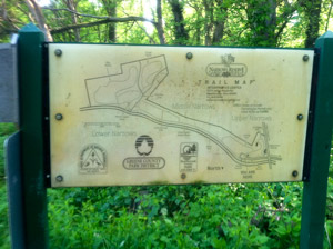
The trail head is off the parking lot where you will see a sign with a trail map. The trail map is generally correct, but not 100% accurate. The map above is closer to reality. The trail structure looks like a bone. The shaft of the bone is the River Trail. On the north end there is the single loop, the Vista Trail. On the south end are the other four loops. The first one is the Cold Spring Trail which sort of scabs itself onto the main trail. The final three all run off the end of the River Trail on the south end of the park, the Meadow Trail, the Big Woods Trail, and the Sugar Bush Trail. It’s pretty hard to lose your way at the Narrows, but if you get confused just head toward the river and go north (up river, against the flow).
Easiest Long Hike
The trail that runs along the river is appropriately called the River Trail. If you want the easiest hike and want to cover most all of the trails go north (left on the River Trail). This will take you to the first loop on the north end of the park, the Vista Trail.
The middle part of the Vista Trail is a nature trail where there are signs giving you various tree names. The trail also gives you access to the Nature Center, bird rehabilitation shelter, and an apiary. The portion of the trail that runs next to the Nature Center is the old road. It’s kind of hard to imagine that being Indian Ripple Road and heading over the Little Miami River. You can also gain access to the Nature Center directly from Indian Ripple Road.
If you do not want to continue further into the park, as you leave the part of the Vista Trail that that is designated as a nature trail, you will see a stair on the left that takes you back down to the parking lot.
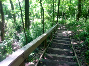
As you continue into the park, toward the end of the Vista Trail, you will come to a steep hill that has steps and handrail built into the hillside. It’s kind of steep in places, so watch your step. The trail will dump you back onto the River Trail. Left takes you back to the parking lot. Right continues you on your way.
As you walk the River Trail you will see places where the river and flows to the river have changed the trail. The river keeps overflowing its banks causing trees to fall. There are also a number of boardwalks that were built to keep you out of some of the muddier sections of the trail. It is not unusual after hard spring rains when the river overflows its banks to find these boardwalks strewn this way and that at different parts of the trail. As you look away from the river, up the hillsides, you will see where rocks have been washed down across the trail from the water cascading down to the river.
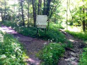
The next turn will be onto the Cold Springs Trail, turn west (right). It will be easy to spot, there is a sign.This trail takes you by an old homestead. If you look carefully you might be able to see the old foundation. You defiantly can see where the old spring comes up out of the ground. Look to the right as you cross the first of two boardwalks. You will see a concrete basin where the spring comes out of the ground. This spring runs year round. You will see bright green foliage growing in the runoff from the spring even in the winter. On the other side of the trail you can see the outline of what appears to be the remnants of a small pond. It is hard to pick out when all the leaves are on the plants, but is evident in the winter months.
Continuing south on the Cold Springs Trail you will come to a point where the trail makes a sharp bend to the left with a trail going off to the right. You want to go left. The trail to the right will take you to Sperling Lane and an alternate entrance to the Narrows Reserve.
Almost immediately, as you head down the trail to the left, you will see a trail heading off to the right that crosses the creek. You want to take that trail. It will take you to an old road that will take you to the three loops on the southern portion of the Reserve.
If the creek is too deep to cross you can take the short detour up to Sperling Lane to the alternate park entrance. From this entrance you will follow the old gravel road to access the three loops on the southern end of the Reserve.
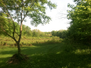
If you continue on the Cold Springs Trail it will take you back to the River Trail. When you reach the River Trail you can go left to get back to the parking lot. If you go right you will cross the creek and end up in the meadow where primitive camping is allowed. (Check with the Park District on camping rules.) In the meadow you can access the Meadow Trail and the Big Woods Trail. You can also follow the old road to access the Sugar Bush Trail.
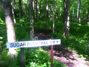
When you reach the old road you want to go right. You will see the sign for the Meadow trail on the left, keep going straight. You will cross the creek and the Sugar Bush Trail will begin/end on either side of the sugar shack. You will see the signs. The Sugar Bush Trail runs through a sugar bush where the sap is harvested and made into maple syrup at the park’s own sugar shack for the annual pancake breakfast. If you go to the left of the sugar shack you will have a steep up a set of stairs built into the hillside. If you would like a little more leisurely hike take the trail starting on the right of the sugar shack. There is a grade, but it is pretty gentle and that allows you to come down the steep section of the trail. If you keep going on the old road it will take you to Sperling Lane and the alternate entrance to the Reserve. If you couldn’t get across the creek this is the way you would come to get to the Sugar Bush Trail.
To continue your hike head back the way you came to the sign that says Meadow Trail. Turn right and about thirty yards ahead you will see the sign for the Big Woods Trail. Turn right onto the Big Woods trail and follow the trail up the hill. This trail has the biggest stand of older trees. You will also come across an old chimney from a farm house. The trail will loop around and bring you back to the river and the Meadow Trail loop.
Follow the Meadow Trail straight ahead and on the right you will see a sign marking the beginning of the River Trail and the way back to the parking lot. There is a creek crossing that sometimes is too high to wade in boots. So you can either take off your boots or trace your steps back to the meadow and turn right. In about seventy-five yards you will see the trail to the right that you took to originally get across the creek. It will bring you to the Cold Springs Trail you can go left or right and the loop will take you back to the River Trail. I recommend going left because if the creek is too high to wade, the River Trail will probably be very muddy between the creek and where the northern turn off to the Cold Springs Trail.
A More Challenging Hike
If you want to make the hike a little more challenging simple reverse the start direction of the hike, go right instead of left and finish the hike on the Vista Trail. This will put every one of the steepest parts of the trail in your path.
The Narrows Reserve is also a good place to see wildlife and wild flowers. I run across deer on a regular basis as well as pileated woodpeckers. The spring showing of marsh-marigolds is spectacular and this year there were grape hyacinths everywhere. Since this post is already too long, I will write about the wildlife and wildflowers another time.

1 Response to The Narrows Reserve