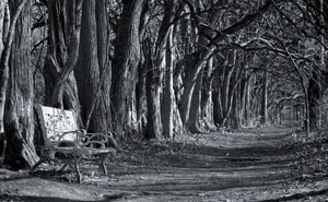
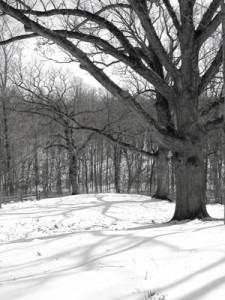
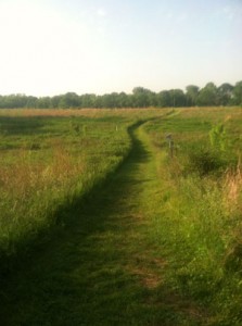
Sugarcreek Metropark, 4178 Conference Road, Bellbrook, Ohio 45305 is a diverse habitat with everything from a meadow to rolling hills. Two of its premier attractions are 550 plus year old oaks (one group known as the “Three Sisters” unfortunately there are only two remaining) and an Osage Orange Tunnel.
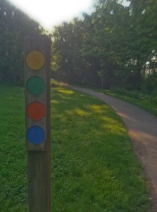
The trails are well marked, wide and road like, which is a good thing since it is one of the most heavily used parks in the area. It is a favorite of runners and hikers alike. On a weekend or holiday you probably will never feel alone. The park is dog friendly, but does require a lease. The trails are all loops, so it is easy to find your way around once get accustomed to the dotted trail markers.
It is possible to get confused when hiking the park. I have had more than one person ask me which way is out. The part that gets most people is the trails overlap which means there will be markers with more than one colored dot. Just remember when you come to an intersection look behind you, ahead of you, and down the trail that intersects for the color you are following. This will help you figure out if you need to make the turn or keep going.
There are also numbers at the various trail intersections to help in navigation of the park. There are paper maps available at the park or online and there are maps strategically placed on the trails. Not having a map should not deter you from hiking the park. Common sense and a general feeling what direction you are going should be enough. If you get confused just ask someone, there should be plenty of people around.
The Montgomery County Park District (MetroParks) operates and maintains Sugarcreek MetroPark. I am not sure you will find too many parks owned and operated by one county, but located in a different county. The reason for this anomaly is by the time the park district was formed land prices in the portion of the county the park was meant to serve were beyond the its means, so land was sought in adjacent Greene County. The park was made up of two major land purchases in the mid sixties. The land was last farmed in 1968.
There are five primary trails varying in length from 3.1 miles to .07 miles in length. The trails run from easy to moderate. There are some steep areas that some might describe as difficult. There is only a little more than 100 feet of elevation gain or lose on the trails. There are two other trails: 1) a .25 mile asphalt handicapped accessible trail in the meadow, and 2) the Big Woods Trail which is across the Little Sugar Creek off of the Green trail. The asphalt wheel chair accessible trail is just to the right after you take the short walk from the parking lot to the main distribution point for all the trails.
Trail Length and difficulty
-
Green Trail ∙ 3.1 miles ∙ moderate (many changes in elevation, one longer up if you follow loop counterclockwise)
- Orange Trail ∙ 1.3 miles ∙ easy (little elevation change)
- Blue Trail ∙ 1.2 miles ∙ moderate (one very steep up if you follow the trail counterclockwise)
- Red Trail ∙ 0.8 miles ∙ easy (little elevation change)
- Yellow Trail ∙ 0.7 miles ∙ easy (mostly flat)
- Big Woods Trail ∙ 1.0 miles ∙ easy to moderate (some elevation gain and lose)
- Handicap Accessible Trail ∙ .25 miles (flat)
Green Trail
The Green Trail is the longest loop in the park taking you by or through most of the various habitats in the park. If you take the trail counterclockwise you will travel along a large meadow which is actually a planted prairie. Depending on the time of year you are at the park the prairie grass will be low because the park does a burn to maintain the prairie. In the late summer the grass will be almost head high. The rest of the trek on the Green Trail will be in the woods.
At marker 9 there is a side trail that will take you across Sugar Creek and on to Spring Lakes Park. Spring Lakes are ponds stocked by the Greene County Park District. Your regular state fishing license is no good here. You will need Greene County fishing permit. There is self registration for fishing licensees at the park. The lakes are stocked once per month with trout October through February and catfish March through September.
At marker 16 you can drop down and head across Sugar Creek again and hit the Big Woods Trail. The trail runs along the creek for a little ways and then you will enter a loop that will bring you back. It’s a nice quiet little trail that can get you off the hubbub of the main trails.
In the winter time the section of the Green Trail (it’s also the Blue Trail) that runs along Sugar Creek can be icy. The area being low keeps it pretty shaded. Combine the shade and all the water running down the hill into the creek it takes a pretty good stretch of warm temperatures to clear the ice and snow. It is passable, but you need to watch your step.
Orange Trail
The Orange Trail has two of the most interesting attractions you will see anywhere. First are the “Three Sisters.” The sisters are 550 plus year old white oak trees. They are something to see. Unfortunately, now there are only two of the sisters left. The park district is starting to talk about them as just “the Sisters,” but they will always be the three sisters to me.
The second attraction on the Orange Trail is the Osage Orange Tunnel. In the late 1800”s there were companies selling a “living fence.” The company would prepare the ground, plant the plants, and then trim them until a perfect hedge was formed. The Osage Orange plants left to grow on their own eventually get big enough when they are not maintained turn into a natural tunnel. It creates a cool oasis and is kind of relaxing.
Blue and Red Trails
The Blue and Red Trail cover a lot of the same ground. The Blue Trail has the distinction of having the longest steepest section of any of the trails. The up is not terribly long, but you will probably be breathing hard by the top. The up part of the trail has uneven stone stairs which adds to its challenging nature. If you want to go down the steep section, follow the trail counterclockwise. The Red Trail is a rather nondescript walk through the woods except for the unusual stand of Sycamore trees on the ridge. Sycamores are water lovers, so you usually see them by waterways. There must me some very unusual water source on that ridge to keep those trees happy. The Sycamores should be easy to spot they have the bark that looks like camouflage.
Yellow Trail
The Yellow Trail loops through the planted prairie. It can be kind of hot out there in the summer time with no shade. One of the interesting parts of the trail is seeing the various grassland birds like red-winged blackbirds, bluebirds, and indigo buntings to name a few.
I have hiked Sugar Creek MetroPark since the 1970’s when it was little more than some old farm roads and narrow paths through a couple of old farms. It has sure grown up over the years. Most of the trails are more road-like now and with the amount of traffic the park gets it’s pretty much a necessity.
The park is a big favorite of runners. You will see them almost every time you hit the trail. In June there is the Sugarcreek 5 miler sponsored by the Ohio River Runners Club and the Dirty Dude Girl Trail Run sponsored by Up and Running. Up and Running also sponsors weekly 8:00AM Sunday morning runs at the Park.
I really like Sugar Creek, but I try to time my visits other than weekends and holidays. There are just too many people. I recommend weekdays early and the winter time to visit the “Three Sisters” and the Osage Orange Tunnel.

